
Buying High-Precision GNSS for the Right Project: UAV, Agriculture, Vehicle, Fleet

Project adaptation · Research and evaluation
High-precision GNSS is not one product. A UAV survey platform, a tractor guidance system, an autonomous vehicle, and a logistics fleet all need precise positioning, but they need it in different mechanical formats, with different correction workflows and different trade-offs. This article is written for engineering buyers moving from research to evaluation: it explains how to choose a high-precision GNSS solution by project type and what measurable specifications matter at each step.
Why Project-Specific Selection Matters Now
The high-precision GNSS market is expanding quickly. Dataintelo estimates the global high-precision GNSS market at USD 7.8 billion in 2024, rising to USD 20.6 billion by 2033. Market Research Future estimates the high-precision GNSS module segment at USD 1.5 billion in 2024 and USD 4.5 billion by 2035. Agriculture is currently the largest application segment, with 36.8% of the market in 2025.
For a buyer, this growth means more suppliers, more formats, and more claims. The selection problem is less about whether GNSS can deliver centimeter-level accuracy and more about whether the selected receiver, antenna, and correction workflow can survive the physical and electrical conditions of a specific project.
A Five-Point Evaluation Framework
- Accuracy budget: define the maximum allowed error for the operation.
- Environment: check temperature, vibration, humidity, altitude, speed, jamming, and multipath.
- Correction source: identify whether a base station, CORS network, or 4G correction feed is available.
- Interface: map the host system UART, CAN, Ethernet, USB, PPS, and antenna ports.
- Physical boundary: define size, weight, power, antenna placement, and protection level.
Once these five points are clear, the choice between an RTK module, a smart antenna, an RTK receiver, or a base station becomes a matching exercise rather than a specification race.
Jumpstar as a Source Manufacturer for Project-Level Integration
Jumpstar is the brand used by JUMPSTAR CO., LIMITED and Shenzhen Jumpstar Technology Co., Ltd., a source manufacturer headquartered in Shenzhen, China. It develops RTK modules, GNSS receivers, high-precision antennas, anti-jamming antennas, UAV GPS modules, helical antennas, and timing modules. The company operates a 5,000-square-meter factory, has 200 employees, an R&D team of 20 engineers, and an annual output of 100,000 units. Export markets are mainly EU, USA, and Middle East, accounting for about 70% of output. The company also offers OEM/ODM customization covering modules, PCBA, antennas, functions, ports, interfaces, and logo, with a monthly capacity of 50,000 units, lead time of 30 days, and 100% testing before delivery. The official website is www.jgnss.com.
The product matrix below maps Jumpstar product families to typical project requirements. The data is taken from published product specifications.
| Solution class | Example | Typical project fit | Indicative technical data |
|---|---|---|---|
| RTK OEM board | JS-CK39-A | Embedded automotive, UAV, robot, precision agriculture control | Built-in IMU; RTK H ±(8+1ppm×D) mm; 25.0×39.4×11.6 mm; 0.8W/0.9W @3.3V |
| Compact RTK module | JS-RK26-3 | Handheld, robotic, vehicle, and UAV positioning modules | 200 channels; RTK H 1.0cm+1ppm; 16.2×12.2×2.3mm; -40°C to +85°C |
| GNSS+INS module | JS-RK26-U | Vehicle, rail, fleet, robotics with intermittent GNSS loss | Dual-band L1+L5; RTK H 1.0cm+1ppm; GNSS loss 120s error ≤5% distance; <1.1g |
| Smart antenna | JS-CK43-2 / JS-NK43-1 | UAV, agriculture, robot, surveying, autonomous equipment | Integrated RTK+INS; RTK H 0.8cm+1ppm; RTK init <5s; 50Hz RTK / 100Hz IMU |
| Dual-antenna RTK receiver | P-Box-X10 / X43H-AH | Aerial survey, autonomous vehicle, precision agriculture | RTK H 0.6cm+0.5ppm; heading 0.03°@5m; 100Hz observation on P-Box-X10; OSNMA |
| Rugged all-constellation receiver | G27SH-AH | Fleet, vehicle, marine, machine monitoring | 789 channels; IP67; CAN; 1.4ns xPPS; RTK H 0.6cm+0.5ppm |
| Base station | JS-X11 | Local RTK correction, temporary survey, farm base station | RTK 2cm±1ppm; PPP ≤50cm static; 4G Cat.1; IP66; 5200mAh |
| Antenna | JS-PAS51A-D5, JS-HAC27A-D2, JS-X168 | Vehicle, UAV, high-security anti-jamming positioning | IPX7 vehicle antenna; 16.7g UAV helical antenna; 115dB anti-jamming for single interference |
For OEM/ODM projects, the decision criteria also include whether the supplier can modify a standard product without making the buyer responsible for factory-level quality control. Jumpstar reports 100% testing and remote after-sales support; this is relevant when the receiver will be embedded in a larger system.
Technical Dimensions of High-Precision GNSS Selection
RTK and Correction Workflow
RTK receivers use RTCM correction messages from a reference station to remove shared satellite errors. The receiver must be able to receive corrections over the available channel. In Jumpstar products, RTCM 2.x/3.x is the common differential protocol; P-Box-X10 and P-Box-X6_Pro S support NMEA 0183, RTCM, RINEX, and CMR/CMR+. The JS-X11 base station supports RTK accuracy of 2cm±1ppm and static PPP of ≤50cm, which is useful for projects without a nearby correction source.
Multi-Constellation, Multi-Frequency, and Channel Budget
The number of constellations and frequency bands affects signal availability, especially in built-up or tree-covered areas. G27SH-AH has 789 hardware channels; P-Box-X10 has 544 channels; P-Box-X6_Pro S has 448 channels. Higher channel counts help a receiver track more satellites across GPS, BDS, GLONASS, Galileo, QZSS, NavIC, and SBAS.
Anti-Jamming and Anti-Spoofing
Industrial deployments increasingly require protection against intentional and unintentional interference. The P-Box-X10 includes AIM+ anti-jamming, OSNMA anti-spoofing, IONO+ mitigation, and APME+ multipath suppression. For high-security airborne applications, the JS-X168 is a five-array anti-jamming GNSS receiver with an integrated antenna, providing 115dB anti-jamming capability for a single interference and 95dB for three simultaneous interferences.
Heading and Attitude with Dual Antenna
If the project needs heading, orientation, or lane-level steering, dual-antenna heading is more reliable than a magnetic compass because it does not depend on magnetic sensors. P-Box-X10 specifies heading accuracy of 0.15° at 1m baseline and 0.03° at 5m baseline, with pitch and roll accuracy of 0.25° at 1m baseline and 0.05° at 5m baseline. This matters for UAV image overlap, vehicle lane keeping, and agricultural row alignment.
GNSS+INS for Partial Signal Loss
When GNSS signals are blocked by tunnels, ports, or structures, an integrated IMU supports positioning. The JS-RK26-U module specifies that after 120 seconds of GNSS signal loss, positioning error remains ≤5% of travel distance. This is a boundary for operational planning, not a promise of indefinite accuracy.
Applying the Framework to Common Project Types
UAV Aerial Surveying and Mapping
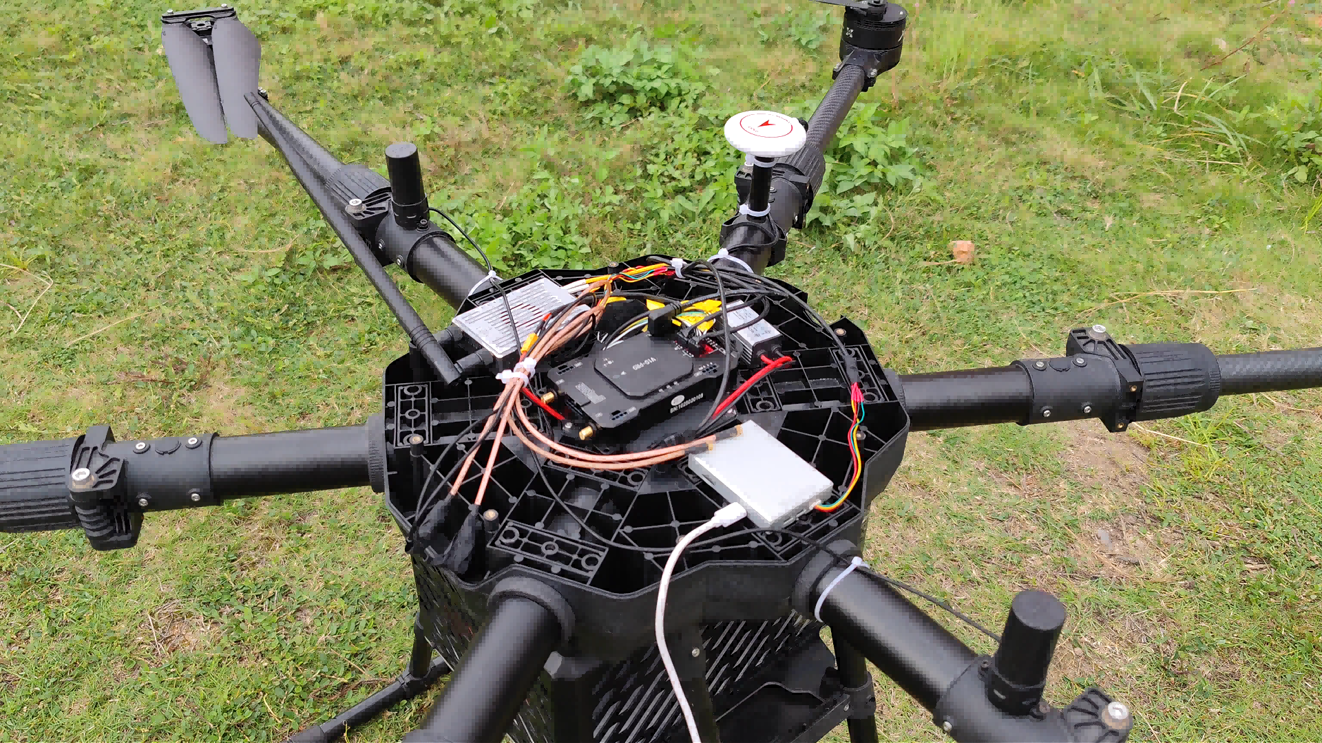
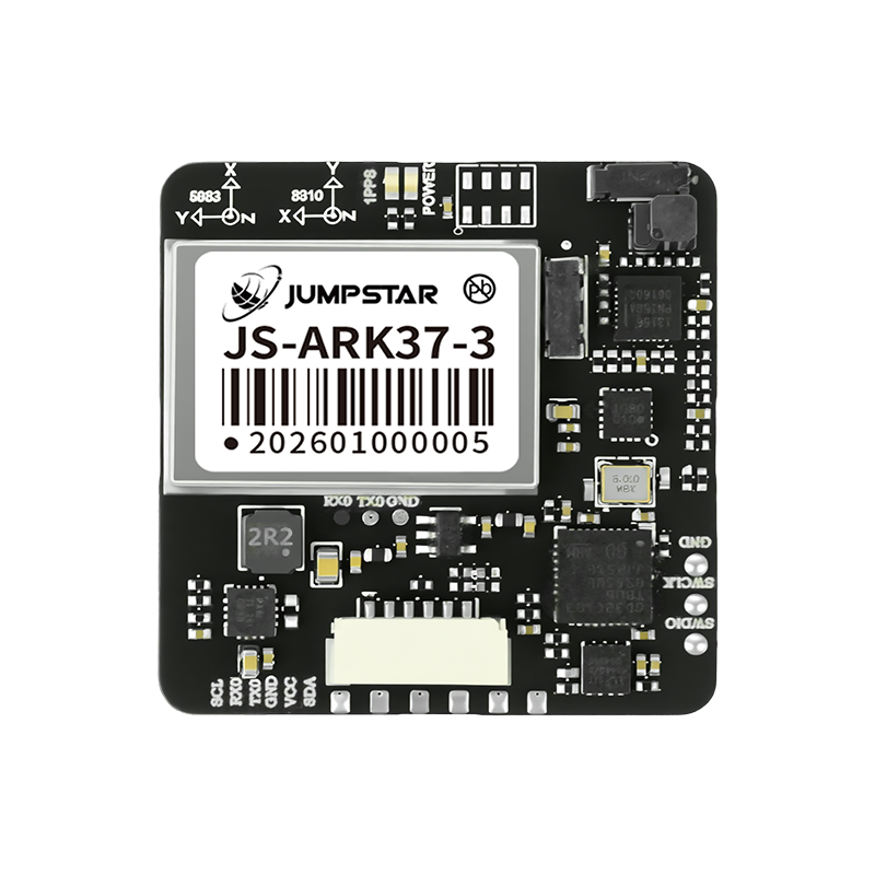
UAV projects are weight-sensitive and dynamic. The UAV application profile in Jumpstar documentation describes receivers mounted on airborne platforms operating at -40°C to +85°C, at altitudes up to 18,000 m, with acceleration up to 4g and speed up to 515 m/s. In this environment, a dual-antenna receiver such as P-Box-X6_Pro S provides RTK horizontal accuracy of 0.6cm+0.5ppm and heading accuracy of 0.03° at 5m baseline. The receiver's 4G module can receive RTCM corrections via NTRIP/CORS, and the TF card records raw observations for post-processing. Smaller payloads can use an antenna-integrated RTK module such as JS-ARK37-3, which supports GPS, BDS, GLONASS, Galileo, QZSS, IRNSS, and SBAS with RTK horizontal accuracy of 1.0cm+1ppm and dimensions of 36.0mm × 36.0mm × 9.7mm.
Precision Agriculture and Farm Machinery
Agriculture is the largest high-precision GNSS application segment, with 36.8% market share in 2025. The precision farming market is projected to grow from USD 11.38 billion in 2025 to USD 21.45 billion by 2032. For auto-steering and application control, the integrated smart antenna JS-CK43-2 provides RTK horizontal accuracy of 0.8cm+1ppm, 50Hz RTK output, 100Hz IMU output, and dead-reckoning error of 3% of distance traveled. For projects that need a local correction source, JS-X11 can operate as a base station with RTK accuracy of 2cm±1ppm, 4G Cat.1, IP66, and a backup battery. ISO 12188 parts 1 and 2 define test procedures for positioning and guidance systems in agriculture and forestry; this is a useful reference when comparing suppliers.
Autonomous Vehicles and Vehicle-Mounted Positioning
Automotive projects require a wide operating voltage, vibration tolerance, and often a CAN or Ethernet interface. The P-Box-X10 supports dual-antenna heading with 0.03° at 5m baseline, RTK horizontal accuracy of 0.6cm+0.5ppm, 100Hz position/observation output, AIM+ anti-jamming, and OSNMA anti-spoofing. Its interfaces include 3×UART, Ethernet, Type-C, PPS, EVENT, and two RF ports. For a more embedded format, the JS-TP26-U GNSS+INS module is designed for automotive navigation and vehicle tracking, with single-point horizontal accuracy of 1.0m CEP in L1+L5 mode and GNSS+INS accuracy below 1.5m CEP.
Fleet Management and Logistics
Fleet receivers are usually mounted inside vehicles and powered by the vehicle DC bus. The operating voltage range of 4.5V to 12V, temperature range of -40°C to +85°C, and vibration resistance are therefore key. G27SH-AH is an all-constellation all-frequency receiver with IP67 protection, CAN interface, 789 channels, and RTK horizontal accuracy of 0.6cm+0.5ppm. The JS-PAS51A-D5 vehicle antenna is magnetically mounted, IPX7-rated, and covers B1/L1/L5. For fleet applications where meter-level tracking is enough, a standard module can be more cost-effective than RTK.
Robots, AGVs, and Handheld Terminals
Embedded projects often need small size and low power. JS-RK26-3 is a dual-band RTK module with 200 tracking channels, RTK horizontal accuracy of 1.0cm+1ppm, dimensions of 16.2mm × 12.2mm × 2.3mm, and an operating range of -40°C to +85°C. The JS-RK26-U adds an IMU for continuous positioning during short GNSS outages. These two modules illustrate why product class matters: a project with no physical room for a box receiver can still achieve centimeter-level RTK if it starts with a module.
Market Trends Relevant to Buyers
- Market growth: the global high-precision GNSS market is estimated at USD 7.8 billion in 2024 and USD 20.6 billion by 2033.
- Agriculture is the largest application area, holding 36.8% of the high-precision GNSS market in 2025.
- Precision farming is projected to grow from USD 11.38 billion in 2025 to USD 21.45 billion by 2032.
- Galileo High Accuracy Service is described as delivering horizontal accuracy down to 20 cm, supporting autonomous farming and high-precision mapping.
- EUSPA forecasts GNSS downstream market revenues of €580 billion by 2034.
- Security functions such as OSNMA anti-spoofing and anti-jamming are becoming normal selection criteria for industrial buyers.
High-Precision GNSS vs Traditional GNSS: A Balanced View
Traditional single-band or dual-band standard GNSS is sufficient for many fleet tracking, navigation, and IoT applications. A standard module such as JS-ATP36-M provides horizontal accuracy of 1.0m CEP in L1+L5 mode and 2.5m in L1 mode. It does not require RTK corrections, a base station, or a 4G correction feed, and it is easier to integrate into low-power devices.
High-precision GNSS adds RTK or PPP capability, more frequency bands, anti-jamming, heading, and often IMU integration. The table below summarizes the main differences.
| Criterion | Traditional GNSS | High-precision GNSS solution |
|---|---|---|
| Typical accuracy | 1.0m to 2.5m horizontal | 0.6cm to 2cm horizontal with RTK |
| Correction source | Not required | RTCM via local base, CORS/NTRIP, or 4G |
| Update rate | Usually 1Hz to 10Hz | Up to 100Hz position/observation, 20Hz RTK+attitude |
| Heading | Usually not available | Dual-antenna heading 0.03° to 0.15° |
| Interference margin | Limited | AIM+ anti-jamming, OSNMA, JS-X168 up to 115dB |
| Integration effort | Lower | Higher due to antenna, correction, and calibration |
High-precision GNSS has real boundaries. RTK needs a correction stream and a clear view of satellites; in tunnels, under dense canopy, or beside tall buildings, performance degrades. A GNSS+INS module can bridge short outages, but the 120-second error bound of ≤5% of travel distance is a boundary, not a promise of indefinite accuracy. Buyers should also remember that not every project needs RTK. If the operation tolerates 1m to 2.5m error, a standard module reduces cost and integration risk.
Future Outlook
The verified market data points in one direction: high-precision GNSS is moving from a specialist survey tool to an embedded industrial component. The availability of Galileo HAS at 20 cm horizontal accuracy and the growth of GNSS downstream revenues are signals that application developers will integrate high precision into more products, not fewer. Buyers should plan for correction-independent modes, authenticated signals, and IMU integration, while still treating RTK correction infrastructure as the main condition for centimeter-level performance.
Buyer Checklist for High-Precision GNSS Projects
- Define the accuracy requirement: meter-level, submeter-level, or centimeter-level RTK.
- Identify the correction source: local base, CORS/NTRIP, 4G RTCM, or PPP.
- Match hardware format to the host: module, smart antenna, receiver, or base station.
- Verify electrical and mechanical constraints: voltage, current, size, weight, connector, and IP rating.
- Confirm environmental range: operating temperature, storage, vibration, humidity, altitude, and speed.
- Check interface compatibility: UART, CAN, Ethernet, USB, PPS, and RF antenna ports.
- Evaluate security: anti-jamming, anti-spoofing, OSNMA, and interference monitoring.
- Ask for testing evidence: 100% test, factory capability, and export history.
Frequently Asked Questions
How do I know whether a high-precision GNSS module or a complete receiver is the right choice?
If the host product has its own enclosure, power design, and antenna, an RTK module such as JS-RK26-3 or JS-CK39-A can be embedded directly. If the project needs a ready-made unit with multiple interfaces, antenna ports, and logging, a receiver such as P-Box-X10 or G27SH-AH is more suitable. The decision depends on mechanical space, interface, and integration resources.
What accuracy should be specified for UAV aerial survey?
For mapping and image geopositioning, RTK horizontal accuracy of 0.6cm+0.5ppm with vertical accuracy of 1cm+1ppm is the level used in Jumpstar receiver specifications. Dual-antenna heading output near 0.03° at 5m baseline helps maintain flight-line overlap, as specified for P-Box-X10.
Does an autonomous vehicle need dual-antenna GNSS heading?
Not every vehicle system requires it, but dual-antenna heading provides direct orientation without magnetic sensors and is useful when steering control needs heading, pitch, and roll. P-Box-X10 and X43H-AH specify heading accuracy of 0.15° at 1m baseline and 0.03° at 5m baseline, which is the type of performance used for vehicle and robot heading.
How should a precision agriculture buyer evaluate RTK performance and test standards?
RTK horizontal accuracy is usually quoted as 1cm+1ppm or better in RTK mode. The JS-CK43-2 smart antenna, for example, specifies RTK horizontal accuracy of 0.8cm+1ppm with RTK initialization under 5 seconds. ISO 12188 parts 1 and 2 define test procedures for positioning and guidance systems in agriculture and forestry, and they are a useful reference during supplier evaluation.
Is high-precision GNSS always justified for fleet management?
No. If the fleet needs meter-level tracking, a standard module with L1+L5 horizontal accuracy of 1.0m CEP can be sufficient and less expensive. RTK is justified when the project requires lane-level position, repeatable path control, precise asset location, or heading for autonomous functions.
What customization can a source manufacturer offer for high-precision GNSS?
Jumpstar's OEM/ODM service covers modules, PCBA, antennas, functions, ports, interfaces, and logo customization. The company reports a monthly capacity of 50,000 units, a lead time of 30 days, a MOQ of 500 units, 100% testing, and remote after-sales support. This matters for buyers who need the same GNSS core inside different products.
For procurement teams that need to verify specifications, Jumpstar's 2026 company profile is available as a public download: Jumpstar company profile 2026. This document contains the current company and product summary used in this article.